
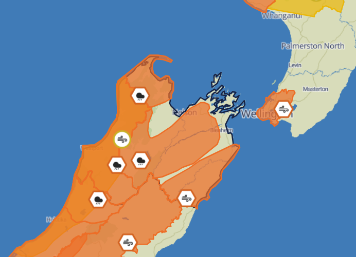
Metservice has upgraded and extended weather warnings in place for much of the Top of the South as a front stalls over the South Island on Thursday.
Heavy rain warnings have now been issued for much of Nelson Tasman from noon on Thursday.
Heavy rain will his Tasman northwest of Motueka first, with an orange heavy rain warning in place from noon Thursday through till 7pm Friday.
The area, which includes Golden Bay, can expect 250 to 350 mm of rain, but possibly as much as 400 mm about the ranges.
Peaks rates of 20 to 30 mm/h are expected during Friday with thunderstorms possible.
The deluge will move across the district with an orange heavy rain warning in place for Nelson and Marlborough between Nelson City and the Awatere River, and also Nelson Lakes National Park.
This area can expect 120 to 180 mm of rain with peak rates of 15 to 25 mm/h expected from Friday morning with thunderstorms possible.
Strong wind is also expected to hit Marlborough southeast of the Awatere River with severe north to northwesterlies gusting 140 km/h in exposed places.
NZTA/Waka Kotahi are urging drivers to take care on the roads with the weather possibly affecting SH60 Motueka to Collingwood, SH6 Hira to Havelock, SH6 Nelson to O’Sullivans Bridge, SH6 O’Sullivans Bridge to Westport SH65 O’Sullivans Bridge to Springs Junction, SH 63 Kawatiri Junction to Renwick and SH 1 Seddon to south of Kaikōura.
"Drivers can expect challenging driving conditions while the bad weather persists and must take extra care on the roads," a statement says.
Tasman District Council's hydrology team say that, based on current forecasts, they expect moderate flooding in the Tākaka River and tributaries, Motupiko River catchment between an annual flood flow and 5-year flood flows, which may see the river flow outside of normal river channels and across adjacent paddocks.
Low to moderate flooding in the Aorere River, Riwaka and Brooklyn Rivers, Wai-iti, Wairoa and Maitai Rivers and main Motueka River is expected, with annual flood flows possible, where rivers are running bank full but contained within banks.
However, allowing for a moderate risk of thunderstorm activity, it would be prudent to plan for slightly higher flows they says, between annual flood flow and 5-year flood flows, where rivers are running bank full and may flow across adjacent low-lying paddocks and across known low points in roads.
"It is very difficult to forecast for thunderstorm activity and heavy downpours, and localised surface flooding is possible across the region. Whilst starting with relatively dry ground, this event is slightly longer duration and has heavy rain with thunderstorms possible later in the event when the ground will be saturated.
"There is a possibility of land slippage across the hills behind Pōhara, Abel Tasman, Richmond and Nelson. The tidal range is moderate at present, but with very strong northerly winds on Friday, there is the potential for larger-than-normal wind-driven waves along northerly facing beaches of Golden and Tasman Bays Friday afternoon through Saturday morning. This includes shorelines between Ruby Bay and Cable Bay."
